


Kemmangudi
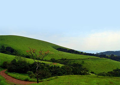
Kemmannugundi: is a hill station in Tarikere taluk of Chikkamagaluru district in the state of Karnataka, India. It is 1434m above sea level. This was the summer retreat of Krishnaraja Wodeyar IV. The station is ringed by the Baba Budan Giri Range, with cascades, mountain streams, and lush vegetation, Kemmangundi’s has ornamental gardens and mountains and valleys views.
Z point -Z point is a vantage point at Kemmangundi and can be reached by a steep uphill trek of about 45 minutes from Raj Bhavan and is another place from which to view the sunrise.
Hebbe Falls -A downhill trek of about 8 km from Raj Bhavan takes one to Hebbe Falls where water streams down from a height of 168 meters in two stages to form Dodda Hebbe (Big Falls) and Chikka Hebbe (Small Falls). Jeeps are available from one particular point to Hebbe falls and they charge around INR 700 to 1200 (for an up and down trip depending on the no of people).
Kallathi falls -Kallathi falls is about 10 km. from Kemmangundi. On the road from Kemmangundi to Tarikere, a deviation takes one to Kallathi falls. It is also known as Kallathigiri falls and Kalahasthi falls. Water cascades from a height of 122 metres and the temple here is attributed to times of the Vijayanagar empire. According to a local legend, this place is associated with the Hindu sage, Agastya.
Mullayanagiri -Mullayanahiri is the tallest peak in Karnataka. It is famous for the temple on the peak and to reach kemmangudi via this route is a scenic beauty and the roads are narrow.
Top Slip
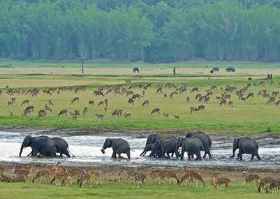
Topslip is located at 800 feet (240 m) above sea level on the Anamalai mountain range. It is popularly known as Anamalai Hills. It is a small place in Indira Gandhi National Park and Wildlife Sanctuary that lies in the Coimbatore District of Tamil Nadu at the southern part of the Nilgiri Biosphere Reserve.Separated from the Nilgiri Hills by the Palghat Gap on the north, the Park is contiguous to the Parambikulam Wildlife Sanctuary (Kerala) toits west and to the Eravikulam National Park (Kerala) and Chinnar Wild life sanctuary. Topslip is about 37 km from Pollachi, the nearest town. It willtake about 1 Hour journey on road from Pollachi to Topslip.
Topslip is one of the most exciting tourist spots in Western Ghats. It is popular because of its natural less human intervented wild life. Parambikulam Wild Life Sanctuary is a must watch in Top Slip. You can see wild animals like Elephants, Wild Goats, Wild Buffalo's, Monkey's etc.,
Valparai
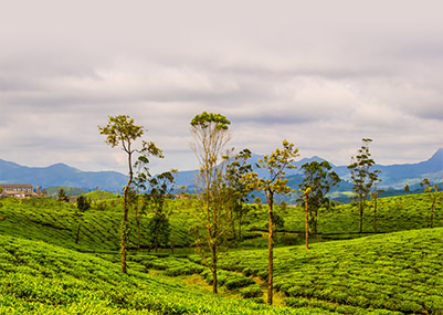
Valparai is a Taluk and hill station in Coimbatore district of Tamil Nadu,India. It is located 3,500 feet above sea level on the Anaimalai Hills range of the Western Ghats, at a distance of 100 km from Coimbatore and 65 km from Pollachi.There are 40 hairpin bends on the way to Valparai from Azhiyar. While major portions of the land is owned by private tea companies, large forest areas continue to be out of bounds.
Valparai is a mid-elevation hill station (Ootacamund is considerably higher). The tea plantations are surrounded by evergreen forest. The region is also a rich elephant tract and is known to have many leopards.
The scenic drive to the town from Pollachi passes through the Indira Gandhi Wild Life Sanctuary noted for elephants, boars, lion-tailed macaques, gaur, spotted deer, sambar, and Giant Squirrels. The area is also rich in birds, including the great hornbill. Water bodies at Monkey falls and Aliyar Dam are also seen en route. A famous place of worship, Balaji Temple also attracts pilgrims. Valparai receives among the highest rainfall in the region during the monsoons (around June). Pollachi is the nearest town from Valparai. It is about 64 km from Pollachi, another Taluk in Coimbatore district. It has 40 Hair Pin Bends from Pollachi to Valparai.
It takes about 1 hour 30 mins to reach Valparai from Pollachi on road State Highways 78.
Valparai is connected to Athirampalli falls by road, but it is a complete Ghat Section. You can travel only in day between 9 AM to 6 PM through this route. This route is a complete adventurous trip as you could see wild animals on the way. It is almost 130 km from Valparai to Chalakudi. But it takes around 4 Hours on roads as it is a Ghat Section.
The Valparai range is also habitat the Nilgiri Tahr, an endemic wild goat. These mountain goats inhabit the high ranges and prefer open terrain, cliffs and grass-covered hills, a habitat largely confined to altitudes from 1200 to 2600m in the southern Western Ghats. Their territory extended far and wide all along these hills in the past, but, because of hunting and large-scale habitat destruction, they now exist only in a few isolated sites like the Anaimalai Hills.
On the way to Valparai you can see many wild animals like Lion Tailed Monkeys, Elephants, Dears, Wild Goats. Sightings of Leopard and Tiger are highly likely.
Chettinad
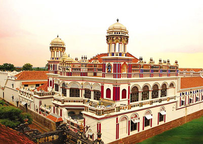
Chettinad is a region of the Sivaganga district of northern Tamil Nadu state, India. Karaikudi is known as the capital of Chettinad[citation needed], which includes Karaikudi and 74 (traditionally 96) other villages. Chettinad is the homeland of the Nattukottai Chettiars (Nagarathar), a prosperous banking and business community. Chettinad is well known for its Chettinad cuisine, mansions, and temples."Chettinad" also means a social caste that specializes in the preparation of food. Chettinads are considered master chefs who prepare food that reflects the excellence that people in Chennai/South India look for in the preparation and serving of food.
Mansions -Chettinad is rich in cultural heritage, art and architecture. It is well known for its houses, embellished with marble and Burma teak, wide courtyards, spacious rooms, and for its 18th century mansions. Local legend has it that their walls used to be polished with a paste made out of eggwhites to give a smooth texture.
Temples -Originally built by early Tamil dynasties like the Cholas, the temples of Chettinad stand testimony to the spiritual beliefs of its denizens. Scattered over the whole place, each temple has its own tank called oorani where water lilies are grown and used for holy rituals. Among the many famous temples are Vairavan Kovil temple, Karpaga Vinayakar temple, Kundrakudi Murugan temple, Kottaiyur Sivan temple and Kandanur Sivan temple.
Travel -The nearest airports are Madurai Airport and Tiruchirappalli International Airport. The largest town in the area is Karaikudi. Trains that run from Chennai to Rameshwaram stop at Karaikudi, Kanadukaathan (Chettinad Station) and Kallal.
Athirappilly
Athirappilly is a first grade Grama Panchayath with 489.00 km² area in Mukundapuram Taluk, Thrissur district in Kerala, India. It is located 60 km from Thrissur city, 70 km northeast of Kochi city, 55 km northeast of Cochin International Airport, and 30 km from Chalakudy town.
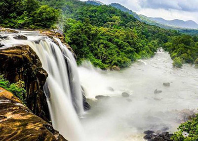
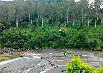
The Athirappilly Falls is situated 1000 ft above sea level on the Chalakudy river, at the entrance to the Sholayar ranges of the Western Ghats, Athirappalli is a scenic combination of forests and little streams. Falling from a height of 80 feet, this is one of the largest waterfalls in the state. Many endangered and endemic species of flora and fauna are found in the forests of the Athirapilly-Vazhachal area. This area is the only place in the Western Ghats where four endangered Hornbill species are seen.
Araku Valley
Araku Valley is a Hill station in Visakhapatnam district in the state of Andhra Pradesh in India. It is a beautiful valley in the Eastern Ghats inhabited by different tribes. Araku Valley is one of the least spoiled and less commercialized tourist destinations in South India. Araku is located at 18.3333°N 82.8667°E.It has an average elevation of 911 metres (2,989 ft).
It is located 114 km from Vishakhapatnam, close to the Odisha state border. The Anantagiri and Sunkarimetta Reserved Forest which are part of Araku Valley, are rich in biodiversity. This valley is surrounded by mountains like Galikonda, Raktakonda, Sunkarimetta and Chitamogondi. Galikonda hill rising to a height of 5,000 feet.